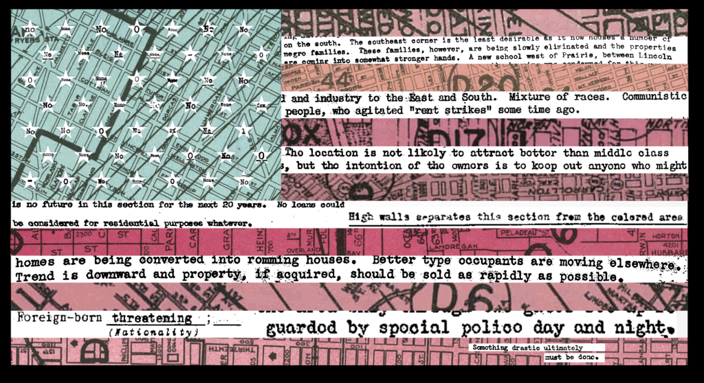
Collage I compiled in Photoshop; it feels heavy-handed to me (I also just really hate American flag art) and is definitely not a standalone, but I wanted to experiment with pulling text forward from the redlining imagery and really explicitly connecting the local scale with the national. The stars contain different responses to the line “Negro: _____” in A, B, and C-graded neighborhoods; blue and red are both cut outs of different sections of maps from different cities; and the white stripes contain text from area descriptions.
I’ve really struggled with writing lately, but here’s a go at some of what I’m thinking about:
In the context of the “residential security maps,” more commonly called “redlining maps,” security is used in the financial sense, defined by Investopedia as “a fungible, negotiable financial instrument that holds some type of monetary value.” Specifically, it refers to mortgage security, intending to estimate the risk of mortgage loans by area.
Red indicates a high risk for investment.
How can we use the assessments to document what happens in the “high risk” areas? How people survive, how people resist, how people find other means of security? We see how investments are protected: “high walls” (Camden, NJ, A1), “special police day and night” (Brooklyn, NY, C23), “the Michigan central R.R. tracks” (Kalamazoo, MI, B4), “a private fence” (Staten Island, NY, B15), “lots of sufficient size” (Rochester, NY, B15), “a gate and guard” (Stamford, CT, A6), “deed restrictions protecting against subversive racial elements” (Los Angeles, CA, C29), to name a few. But how are investments threatened? We see “mixture of the races,” “communistic people,” and “rent strikes” in Brownsville (Brooklyn, NY, D10); “a decline in values following the strike at Montgomery Ward’s and other labor troubles of 1937” in Kansas City (MO, D27, D28, and D30), Melrose Park has “a bad reputation for crime and vandalism” (Chicago, IL, D18).
There is more than the securing, the fixing, the damning in HOLC’s documentation; there is tension. The repeating phrase the area/town/land has no future points to organized abandonment, naturalized to the extent that even terrain descriptions for D-graded neighborhoods read “Negro servants” or “high-grade Negro” while terrain descriptions for A, B, and C-graded neighborhoods read simply “level” or “rolling.” This abandonment naturalized even as the State makes massive interventions into the economy and structure of the housing market.
These grades produced holes in access to capital, but people still need places to be. Contract sellers and other predatory lenders stepped in: organized violence.
My goal in this visualization is to surface tensions, abandonments, violences, and survivals that produce the State. The bottom quote, the only in red, quotes from tract D83 in South Chicago: “Something drastic ultimately must be done.”
Further investigations:
Can these documents serve as an archive of resistance, as evidence of financial punishment for care and resistance?
I came across instructions to sell property in one area “as quickly as possible;” what else are investors and owners encouraged to do? How do these encouragements track in “white flight” and the organized violence enacted by contract sellers?
More about the history of the Contract Buyers’ League in Chicago and similar efforts elsewhere and these groups’ relationships to security/securities.

This entry is licensed under a Creative Commons Attribution-NonCommercial-ShareAlike 4.0 International license.